skip to main |
skip to sidebar
Second part of my walking around the Riverside/White River area.
 Intersection of White River Parkway/30th Street and 30th Street/29th Street. This area had the most change in my years of living in this area. I took some photos around here to illustrate and explain. First off, looking down this street, it used to be you could go down that way to the next street down, only to turn right to that street. Technically you can still go down there, but most of it was repurposed into parking spots, and the rest was incorporated into park land for Riverside Park. In fact, it kinda looks a little obvious that they did that. I took a shot of that.
 A somewhat better view of the street. It's strictly one-way now, and goes to 30th Street. Looking down, that's 30th Street, and it used to be you could go down the other way, but in a limited fashion. Behind me, I came from White River Parkway. It's an odd intersection, really. Turning right from where I am, would send you to 29th Street...
Okay, if you're still confused, let's say you're standing at this intersection where this shot was taken...
Going towards you BUT turning left goes from one-way 30th Street into two-lane 30th Street, going up used to go to the next street (E Riverside Dr), but is now parking space/park land, turning right at where you're standing goes into one-lane 29th Street, and going towards you but keeping straight (going behind you) keeps you on the same street, but it's now White River Parkway (one of at least three streets in and around this area to share that name - one is an East Drive, one is a North Drive). If you're still confused, I drew something out to probably help...

A little more background: Where those houses are in the distance, that used to be the site of the old Riverside Amusement Park. The park closed down in 1970, the rides/anything else left standing were tore down in 1978, and the land was fenced off, unused, and abandoned until 2000, when construction on the River's Edge subdivision started. Because of that, one of the streets next to E Riverside Dr (White River Pkwy E Dr, see below) was rerouted to connect with E Riverside Dr from 30th Street. The original entry way to White River Pkwy E Dr was blocked off a few feet from entry and turned into a parking lot for the nearby Naval Armory as well as a bike trail. Below are shots from that area.
And how the hell do I know all this stuff? Well, you don't live in an area for 14 years without seeing stuff and noticing stuff.
 A shot of the Naval Armory at the intersection. For such an old building (I think it dates back to the 1930s), it still looks damn good.
 Okay, where those houses are, that used to be abandoned land (see above), and where those parking lots are used to be the original route of White River Parkway East Drive. Due to construction, part of that street was rerouted. I took a shot that provides a better view of the original route (now parking lot space for the Naval Armory as well as a bike trail)...
 Better view of what is now a bike trail/Naval Armory parking space from the other side. Took a bit of walking to get there, too. I think the bike trail is the only part of the original route that remains. That wall on the far right, is where various plants and the White River is.
 Okay... See the sign on the far left? Continue to the right of that sign on the pavement below, you're on the bike trail/original route of this street. Continue foward past of that sign (i.e. go off on the road from where I was standing when I took this shot), and you're on the new route, that connects to E Riverside Dr. Continue to the far left, past the sign (going towards me and turning left), and you're on the remainder of the original route. The street, despite all the moving and building, still goes up to 38th Street.
 Intersection of 30th and E Riverside/White River Pkwy E Dr. See that crease going across the grass down there? That used to be where you could turn right on E Riverside. Also, up until 2000, that street ended at 30th due to much of what I explained (or tried to explain) up there.
 Back to that one shot, the one with the sign. I turned around, and this is the rest of that route. It's untouched, save for the houses on the right... and even that ends after another block or two put in by construction. The last three shots are me walking down this street from this point to 38th Street.


 Well, those are all the pictures I took. I don't know when I'll go out and take more, but I hope they look as good as these (well, some of them don't look that great; there were issues with colors and brightness that I later fixed or tried to fix).
This is a pretty big-ass post, I am saying that right now... so much so, I'm splitting it into two parts. But, it's for a good reason: I wanted to take photos of this area for a long time.
The first two shots aside, I lived in that area of town for 14 years: from 1986 until 2000. There has been quite a bit of change, including street-rerouting construction (more on that later). That said, let's get to this!
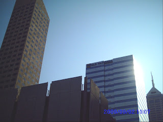
First off, these two shots were taken downtown, at Ohio and Capitol:
 This is the Indiana State Capitol. It's a very nice building, and this was the only shot I took. I would've taken at least two more, but then my bus came.
 I turned around, pointed the camera up, and took this shot. I really like this one.Now, the remaining shots are from the Riverside Park/White River area. It's a damn nice area, with parks, golf courses, and... it just looks so fucking beautiful. And hey, if I do some more digital coloring, these double as good ol'-fashioned background fuel!
 This is the intersection of 16th and E Riverside Drive. For some reason, it used to be either "North Riverside East Drive" or "East Riverside Drive". I always used "East Riverside Drive" whenever I sent letters or other mail. But, this is a street that runs north and south, so they renamed it slightly, based on where it was next to the White River. Now it's E Riverside Drive. So, as an example, an address there would now be "2001 North E Riverside Drive" instead of "2001 East Riverside Drive". That sounds weird, but that's the way it seems it is.
 This is the old house I grew up in. It kinda looks a bit worse since I was last there years ago (and, uh, two weeks ago, as I was looking for spots to take photos from). That birdbath and some of the bushes are still there. What is no longer there are the awnings (we took those down when we lived there, but still) and a big-ass tree that SHOULD be in the center of this shot. I still cannot believe they cut that tree down, man!
 Front view of said house. That tree on the left, is, by the best of my recollection, still there.
 You can't see the street, but this was taken at the intersection of 21st and E Riverside. What is on the far left side is a golf course, and it used to be that sometimes, I would find golf balls in the street or they would sometimes fly into windows.
 I'm trying to find information on the structure in the center. That has been there for many years, and is named after the person responsible for the construction of Riverside Park, Thomas Taggart. Heck, he's responsible for the entire parks system here in Indianapolis. Indy Parks headquarters is not far from this spot.
Now, the area around this structure didn't always look like this. 20 years ago, that median wasn't even there, and there was a second road where playground equipment is now (on the far right side). That was filled in and built over due to expansion of the recreation center and the erection of said playground equipment.
 Close up of Taggart Arch (I think that's what it was called; I'll have to check again...) I wish I could get closer, or even inside... but they put in a fence around it because of vandals. Damn vandals and their damn vandal-ing! Dammit!
 My attempt at a ground-view shot. I kneeled down and held the camera down to the ground. I wanted to get the shot juuuuuust right... but it just doesn't seem that way. It'd look a bit cooler if that damn fence wasn't there.

 These two shots were taken within feet of each other. The odd thing about the second one is that, if this was taken at a MUCH earlier time, I would be standing in the middle of a street. I said earlier that in order to expand the nearby recreation center and put in other improvements, changes had to be made, medians had to be put in, and streets had to be altered or eliminated altogether. I seem to like these two, but again, I wish I could've taken shots of the arch from inside.
 Would you believe this mighty lake started out as a mere rain puddle? It's not even 20 years old. I'm pretty sure it started out this way. I mean, I used to pass this area on the way to school for many years.
Anyway, years ago, there was severe weather in the area over several nights, and it left behind a big puddle (about 1/4th the size of the lake). Over time, it just stood and stood until it was made into a lake. (I think the drainage pipe that was put in near it - somewhat visible on the left - had quite a bit to do with its lake-ification.) For a while, there was fencing around it, but now there isn't.
That's the end of the first part. The second part covers the rest of my walking around this area - including farther up the street that now connects to E Riverside - even though, just a few short years ago, it didn't.
It took a while, but here's another batch of photos. Here are some of my nephew sleeping:


 Okay, that last one is not of him sleeping, but he just looks so adorable!
Um, here are some of streets near my home:
 Intersection of 41st and Bolton. Going left on 41st here will lead to a dead end. A school playground blocks that part of street off.
 Intersection of 41st and Campbell. If that minivan is the focal point, than something something something else. I did the best I could to not make it look overexposed, but it still looks like the sky is glowing white. The same problem persists in other shots I took as well.
 45th and Campbell, looking down Campbell. I kinda don't like this shot, the "going down" doesn't look as straight as the others, thus no focal point (in some of the earlier street shots, there was some perspective/focal point stuff, as if you were looking down the street... I think there's little of that here).
I got some more, at least two more posts worth, as well as some stuff I found out about the area I took them in, as I lived in that area of town for many years.
 Intersection of White River Parkway/30th Street and 30th Street/29th Street. This area had the most change in my years of living in this area. I took some photos around here to illustrate and explain. First off, looking down this street, it used to be you could go down that way to the next street down, only to turn right to that street. Technically you can still go down there, but most of it was repurposed into parking spots, and the rest was incorporated into park land for Riverside Park. In fact, it kinda looks a little obvious that they did that. I took a shot of that.
 A somewhat better view of the street. It's strictly one-way now, and goes to 30th Street. Looking down, that's 30th Street, and it used to be you could go down the other way, but in a limited fashion. Behind me, I came from White River Parkway. It's an odd intersection, really. Turning right from where I am, would send you to 29th Street...
 A shot of the Naval Armory at the intersection. For such an old building (I think it dates back to the 1930s), it still looks damn good.
 Okay, where those houses are, that used to be abandoned land (see above), and where those parking lots are used to be the original route of White River Parkway East Drive. Due to construction, part of that street was rerouted. I took a shot that provides a better view of the original route (now parking lot space for the Naval Armory as well as a bike trail)...
 Better view of what is now a bike trail/Naval Armory parking space from the other side. Took a bit of walking to get there, too. I think the bike trail is the only part of the original route that remains. That wall on the far right, is where various plants and the White River is.
 Okay... See the sign on the far left? Continue to the right of that sign on the pavement below, you're on the bike trail/original route of this street. Continue foward past of that sign (i.e. go off on the road from where I was standing when I took this shot), and you're on the new route, that connects to E Riverside Dr. Continue to the far left, past the sign (going towards me and turning left), and you're on the remainder of the original route. The street, despite all the moving and building, still goes up to 38th Street.
 Intersection of 30th and E Riverside/White River Pkwy E Dr. See that crease going across the grass down there? That used to be where you could turn right on E Riverside. Also, up until 2000, that street ended at 30th due to much of what I explained (or tried to explain) up there.
 Back to that one shot, the one with the sign. I turned around, and this is the rest of that route. It's untouched, save for the houses on the right... and even that ends after another block or two put in by construction. The last three shots are me walking down this street from this point to 38th Street.


